Creation of electronic Terrain and Obstacle Data (eTOD) and Aerodrome Map Database (AMDB) as the next stage at digitalization of aeronavigation data
Created on 18.04.2019 16:20
(1).jpg)
Kuralbekov Ernat,
Head of Flight Procedure and Map Design
Department for managing Aeronavigation Information of the
RSE "Kazaeronavigatsia"
Progress does not stand still and with the technology development, the International Civil Aviation Organization demands on flight safety by increasing air traffic and number of airfields. One of these requirements is the provision of electronic terrain and obstacle data (eTOD) and aerodrome map data (AMDB).
The creation of eTOD and AMDB is also envisaged by the Enterprise Development Program of the RSE “Kazaeronavigatsia”, approved by the order of the Civil Aviation Committee Chairman; and the Target Program for development of the aeronautical information management system of the Republic of Kazakhstan, approved by the order of the Minister of Transport and Communications of the Republic of Kazakhstan.
Along with international and program documents, the creation of an eTOD is noted at the National Rules for Provision of Aeronautical Information in Civil Aviation, approved by order of the Minister for Investment and Development of the Republic of Kazakhstan.
The necessity for deeper integration of aviation planning issues on the regional and state level is considered circumstantially at the Global Air Navigation Plan (Doc 9750-AN / 963 Fifth Edition - 2016). In this document, states are offered necessary solutions by introducing consensus-approved Aviation Systems Block Upgrade (ASBU), which define the modernization strategy for the aviation industry.
The modernization of the existing Integrated Aeronautical Information Base has enabled the state to make significant progress and fulfill its international obligations by providing aeronautical information and data in electronic form as data sets in globally approved formats.
a, Almaty, Atyrau.
Elimination of non-conformities EANPG (European Air Navigation Planning Group)
At the 17th Session of the EANPG, inconsistencies were identified due to the lack of data in the region4 in three airfields: Astana, Almaty, Atyrau.
.jpg)
Below is a snapshot of the current AIP (Aeronautical Information Collection) page, which shows the data on the terrain and obstacles by area.
Data provided respond all requirements of ICAO documents. The aeronautical inconsistencies identified by the EANPG, regarding the provision of terrain and obstacle data in Area 4, were eliminated by engaging experts from a software vendor company. Data on the specified aerodromes are provided in full.

eTOD (Electronic data sets on terrain and obstacles)
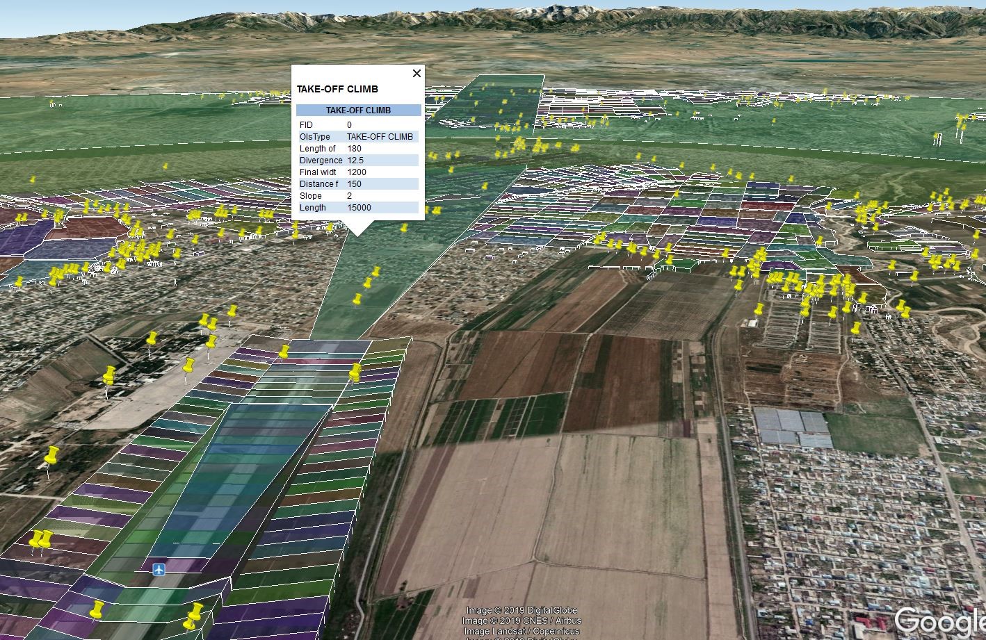
Electronic data on terrain and obstacles is a digital display of relief terrain and obstacles presented as a form of data sets.
The relief dataset is a digital representation of terrain height at several distinct points. The main features of a terrain database include the geometric distribution / position of discrete points, the horizontal / vertical reference point, and specific units of measurement. In the context of eTOD, terrain is defined as the "Earth’s surface”, containing natural objects such as mountains, hills, ridges, valleys, ponds, permanent ice and snow and excluding obstacles."

The obstacle database is a digital representation of the obstacles, which includes horizontal and vertical components. In the context of eTOD, obstacles are defined as all stationary (temporary or permanent) and mobile objects or parts thereof, which
a) located on a sector, intended for ground movement of the aircraft;
b) spread over a specific surface designed to protect an aircraft in flight;
c) stand outside the specified surfaces, but which were assessed as important for air navigation.
Covered Areas for electronic terrain data and obstacles are defined as:
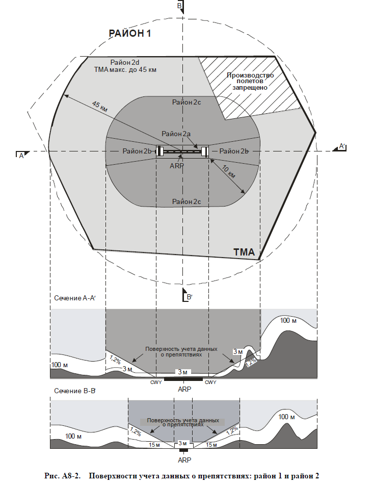
- Area 1: the entire territory of the state (Fig. A8-2);
- Area 2 is a zone within a radius of 45 km from the control point of the aerodrome and is divided into areas 2a, 2b, 2c and 2d (Fig. A8-2);
- Area 3: an area adjacent to the aerodrome working area , which in the horizontal direction extends from the side edge of the runway at a distance of 90 m from the axial line of the runway and 50 m from the side edge of all other parts of the aerodrome working area (Fig. A8-3);
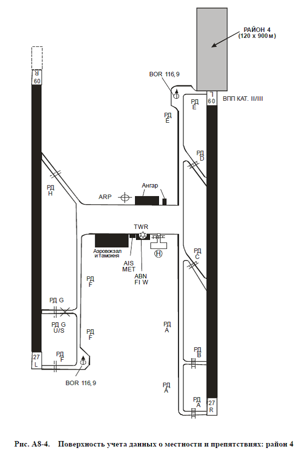
- Area 4: a zone, extending to a distance of 900 m from the runway threshold and 60 m from each side of the runway extended axial line to the runway approach direction, equipped for performing precision approaches in category II or III (Fig. A8-4).
Создание электронных данных о местности и препятствиях (eTOD) и картографической базы данных аэродрома (AMDB) как очередной этап цифровизации аэронавигационных данных
Создана 18.04.2019 11:51
(1).jpg)
Куралбеков Ернат,
Начальник отдела дизайна летных процедур и картографии
Департамента по управлению аэронавигационной информации
РГП «Казаэронавигация»
Прогресс не стоит на месте и с развитием технологий, увеличением воздушного транспортного потока и количества аэродромов Организация международной гражданской авиации предъявляет все больше требований к обеспечению безопасности полетов. Одним из таких требований является предоставление электронных данных о местности и препятствиях (eTOD) и картографических данных аэродромов (AMDB).
Создание eTOD и AMDB также предусмотрено Программой развития предприятия РГП Казаэронавигация, утвержденной Приказом Председателя комитета гражданской авиации и Целевой программой развития системы управления аэронавигационной информацией Республики Казахстан, утвержденной приказом Министра транспорта и коммуникаций Республики Казахстан.
Наряду с международными и программными документами, создание eTOD отмечено в национальных Правилах обеспечения аэронавигационной информацией в гражданской авиации, утвержденных приказом Министра по инвестициям и развитию Республики Казахстан.
Необходимость более глубокой интеграции вопросов авиационного планирования на региональном и государственном уровне подробно рассматривается в Глобальном Аэронавигационном Плане (Doc 9750-AN/963 Пятое издание – 2016год). В Данном документе государствам предлагаются необходимые решения путём введения одобренных на основе консенсуса систем блочной модернизации авиационной системы (ASBU), которые определяют стратегию модернизации авиационной отрасли.
Модернизация существующей Интегрированной базы аэронавигационной информацией позволила государству существенно продвинуться вперед и выполнить свои международные обязательства по предоставлению аэронавигационной информации и данных в электронной форме в виде массивов данных в обще одобренных на глобальном уровне форматах.
Устранение несоответствийEANPG(Европейская группа аэронавигационного планирования)
На 17 Сессии EANPG были установлены несоответствия по отсутствию данных в районе4 в трех аэродромах: Астана, Алматы, Атырау.
.jpg)
Ниже приведен снимок страницы актуального AIP (Сборник аэронавигационной информации), на котором показаны предоставляемые данные о местности и препятствиях по районам.
Предоставляемые данные отвечают всем требованиям документов ИКАО. Аэронавигационные несоответствия, выявленные EANPG, касательно предоставления данных о местности и препятствиях в районе 4 были устранены путем привлечения к работе специалистов компании-поставщика программного обеспечения. Данные по указанным аэродромам предоставляются в полном объеме.

eTOD (Электронные массивы данных о местности и препятствиях)
Электронные данные о местности и препятствиях - это цифровое отображение рельефа местности и препятствий, представленное в виде наборов данных.
Набор данных рельефа - это цифровое представление высоты местности в нескольких отдельных точках. Основные характеристики базы данных местности включают геометрическое распределение / положение дискретных точек, горизонтальную / вертикальную точку отсчета и конкретные единицы измерения. В контексте eTOD местность определяется как «поверхность Земли, содержащая природные объекты, такие как горы, холмы, хребты, долины, водоемы, постоянный лед и снег и исключающие препятствия».

База данных препятствий - это цифровое представление препятствий, которое включает в себя горизонтальную и вертикальную составляющие. В контексте eTOD препятствия определяются как: все стационарные (временные или постоянные) и мобильные объекты или их части, которые
а) расположены на участке, предназначенном для наземного движения летательного аппарата;
b) простираются над определенной поверхностью, предназначенной для защиты воздушного судна в полете;
c) стоят вне указанных поверхностей, но которые были оценены как важные для аэронавигации.
Охватываемые районы для массивов электронных данных о местности ипрепятствиях определяются, как:
– район 1: вся территория государства (Рис. А8-2);
– район 2 представляет собой зону в пределах радиуса 45 км от контрольной точки аэродрома и подразделяется на районы 2а, 2b, 2с и 2d (Рис. А8-2);
– район 3: зона, примыкающая к рабочей площади аэродрома, которая вгоризонтальном направлении простирается от боковой кромки ВПП на расстояние90 м от осевой линии ВПП и на расстояние 50 м от боковой кромки всех другихчастей рабочей площади аэродрома (Рис. А8-3);
– район 4: зона, простирающаяся на расстояние 900 м от порога ВПП и 60 м скаждой стороны продленной осевой линии ВПП в направлении захода на посадкуна ВПП, оборудованную для выполнения точных заходов на посадку по категорииII или III (Рис. А8-4).
.png)

Today, electronic data on the terrain and obstacles have been created for 8 largest aerodromes of Kazakhstan. The data users are companies such as Lufthansa Systems, NavBlue, Jeppesen, SpiceJet, Brussels airlines, etc. Basically, airlines use electronic data on the terrain and obstacles to calculate the maximum take-off weight.
Spheres of application
The addition of new terrain and obstacle databases to the Integrated Database has opened up new opportunities to the State provider of air navigation services, particularly for air traffic controllers, and final users (airline pilots) of aeronavigation information and data, in the following areas:
a) a ground proximity warning system with an assessment function of the relief terrain in the direction of flight and a Minimum Safe Altitude Warning system (MSAW);
b) identifying alternate circuits for using emergency during a go-around or takeoff;
c) an analysis of the aircraft operational limitations;
d) construction of flight circuits by devices (including a circle flight);
e) determination of the reduction procedure for en-route flight and the place of an emergency landing;
f) ground control and monitoring (A-SMGCS);
g) forming aeronavigation charts and on-board databases.

This data can also be used for other applications, such as flight simulator and technical vision systems, and can assist in determining height restrictions or removing obstacles that are dangerous to air navigation.
AMDB (Aerodrome Map Database)

Purpose
1. Determining the position of aircraft on the ground regarding the runways, taxiways and airport constructions without the necessity and adaption for paper maps.
2. A tool for determining, maintaining and restoring situational awareness.
3. It helps pilots to train and locate the aircraft regarding to:
- runway;
- Taxiways and pre-start points on taxiways;
- Parking places.
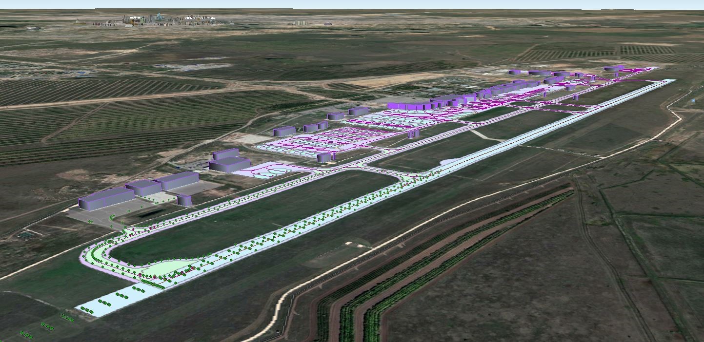
Aerodrome map data blocks contain the aerodrome map data, consisting of the aerodrome elements. Data elements are divided into classes, where each class represents a general (main) category of the corresponding elements.
AMDB is organized from 11 classes (featureclasses), which are:
1. runways;
2. Helipads;
3. taxiways;
4. kaprons;
5. vertical structures;
6. construction areas;
7. Water surfaces;
8. The most dangerous locations (hotspots);
9. aerodrome surface routing network;
10. surface lighting;
11. and quality data.
.jpg)
Starting from 2019, the aerodrome map database is available for two main aerodromes in the country: Astana and Almaty. The data for the database obtained both directly from the airport authorities, and by digitizing satellite images.
Areas of application
Blocks of map data of the Astana and Almaty aerodromes are used in the following application air navigation areas :
a) compilation of aeronavigation information, associated with the aerodrome, including NOTAM;
b) resource and aerodrome facility management;
c) edition of aeronavigation maps;
d) training / flight simulators and artificial vision systems.
The planned upgrade of ATM systems to the required level with the routing function will allow AMDB data to be used for:
1) position and route information, including moving maps, indicating the location of own ship, land traffic control and monitoring (for example, A-SMGCS);
2) traffic information, including observation, detection and warning of unauthorized runway departures.
Creation of AMDB for Astana and Almaty aerodromes will facilitate the operating process at these large aerodromes, which is a complicated combination of many activities, carried out by different stakeholders (pilots; air traffic controllers; and on platforms ground transportation operators; crews, performing reconstruction and maintenance aerodrome infrastructure; personnel, responding to hazards; and safety experts, flight operations personnel). All of them have to work smoothly for ensuring safe and efficient operations at the aerodrome. The central source of data acquisition for making correct operational decisions has become the Aerodrome Map Database, which is formed on the basis of industry standards and in accordance with the provisions of ICAO.
The upgrade also made possible a full-scale transition to the production of aeronavigation information publications and aeronavigation maps from the integrated aeronavigation information database, with its subsequent readiness to feed data of a guaranteed quality the air traffic control system and control system ground movement and monitoring (A-SMGCS).
Making the conclusion, at the moment, digitalization is a native process of transition to an information society, maintaining competitiveness, improving technology and development in general. It has covered almost the entire world and all areas of activities. In our country, digital transformation promoted by the state program "Information Kazakhstan", approved in 2013. And, according to the program, “for ensuring the growth of the transport and logistics industry requires the implementation of a transport system which would help to increase transit capacity by managing vehicles, enhancing transport security through prompt information processing and developing optimal and rational decisions and controlling influences.”
3053 views
 Our company
 News
News
 Activities
 Online Flight plan
 AIS
AIS